Capitol Reef: the Unknown Gem of Utah?
- CampBrood

- Jan 20, 2021
- 5 min read
Updated: Mar 1, 2024
Capitol Reef provides a great experience for families with a wide variety of hikes, drives, historical petroglyphs and settlements. Here is a brief list of features your kids will enjoy:
Scenic drives - its difficult to focus on the road with the spectacular views
Petroglyphs from the Freemont area Natives
The Gifford Homestead of the Mormon settlers and Pie
Hickman Bridge Trail

What's it Like Driving into Capitol Reef?
One of the lesser advertised treasures of the national park system is Capitol Reef. When people think of out West they immediately mention Arches, Bryce, and Zion. Capitol Reef was one of our favorite spots. East of Torrey, Utah the drive into and out of the park is breathtaking. We typically take more pictures of our hikes but we may have taken more pictures from the truck this time. The views are memorable. Chimney Rock and Twin Rocks are between Torrey and the visitors center and can be seen from highway 24. I'm disappointed that we were so enamored with the view that we forgot to take pictures of some of these to share.


One of the lesser advertised treasures of the national park system is Capitol Reef. When people think of out West they immediately mention Arches, Bryce, and Zion. Capitol Reef was one of our favorite spots. To watch some facts on Capitol Reef click here or continue reading below
What is the History of Capitol Reef National Park?
Natives inhabited the Freemont Area from 800-1250 AD. The petroglyph viewing area has adequate parking and a easy boardwalk. As you view the rock, petroglyphs start to lift off the surface and reveal themselves. The more you look the more the images seem to come alive. Its fun to ask others what they have seen and then pass that knowledge along to people that start looking as you are walking out. These petroglyphs are very similar to those viewed at Delicate Arch Trail. You can see those pictures here: Arches National Park: Delicate Arch Trail By road, the distance between these two petroglyph panels is 156 miles. I can't imagine walking the 10 mile round trip distance from my house to town. Did the same person create these drawings. How did petroglyphs, similar in style, show up in places so far apart?


When did the Mormon Pioneers live in Capitol Reef National Park?
Mormon pioneers discovered the area in 1880 and named the area Fruita in 1902. Water sourced from the Fremont River allowed for the humans to survive here. Surrounded by red rock the river provides fertile soil and the ability for vegetation and humans to survive. Fruit trees from their farming in the beginning of the 20th century are alive and well. Around Fruita live Marmots. We did see a Marmot crossing sign but never saw a Marmot. So if you see something like a ground hog in Capitol Reef it is probably a Marmot and enjoy your sighting.
Today, Fruita is home to the Gifford Homestead where there is a barn, agricultural area, store, school, and other remnants of their life here. Additionally, located in Fruita is the Fruita campground run by the National Park Service. The campground has a dump station, potable water, and restrooms, but no hookups. We read that there is a store in Fruita that sells pies and other goods. We arrived around lunch time and the pies were sold out. So, we learned to arrive early. After our Hickman Bridge trail hike the next morning, we quickly made it to the Gifford Homestead again, early, and there were pies and cinnamon rolls available. We bought pies. I was underwhelmed and my wife said it was one of the best crusts she's ever eaten. So, to review a little further, we ate all the pies that we purchased and the brood asked for more!
After our pies we took the scenic drive and toured down the grand wash.
What is it like driving Grand Wash in Capitol Reef National Park?
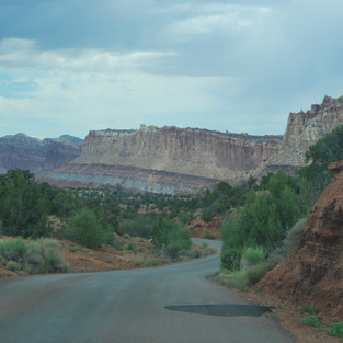
The views of Grand Wash are some of the best we've ever seen. We noticed clouds as we entered the Grand Wash and went a little distance just to get a quick look. We didn't want to travel too far and get caught in a storm and flash flood. The cliffs are tall and the road is very accessible for SUVs and trucks. Go slow as there are blind corners and not enough room for opposing traffic in many places. As you can see from the pictures the sandstone and other geology is varied and offer a unique experience. We were caught by the cliff walls with many little holes and pockets in them. The scenic drive is setup for most vehicles. We wouldn't recommend Class A motorhomes but small Class Cs could make the drive. There are a few drainage areas that would be of concern for long wheelbases.


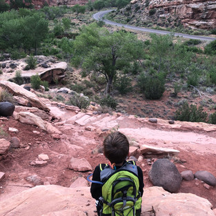
What is it Like Hiking Hickman Bridge Trail in Capitol Reef National Park?
Hickman Bridge Trail is a nice beginner trail with some elevation and beautiful panoramic views. The trail is accessed East of the Fremont Areo on the North side of Highway 24. The trail is just under 2 miles round-trip with elevation of 400 feet. We hiked the trail at dawn and met up with one other family. In the morning it was quiet. We enjoyed the terrain, views, and being able to walk under and around Hickman Bridge. For more details on the trail we've developed a separate post which can be read here: https://www.campbrood.com/post/capitol-reef-hickman-bridge-trail


What Else Can you Do in Capitol Reef National Park?
We didn't even have time to go to cathedral valley or the waterpocket fold area. What a shame. During our trip planning, we attempted to get this drive in. However, it would not fit into our schedule. The National Park Service recommends that people driving into the Valley stop into the visitor's center for road conditions before traveling out. The driving loop is 6-8 hours. This was our biggest hesitation. With young children we didn't want to put them through more time in the truck. Its roughly a 60 mile loop that offers access to many hikes, viewpoints, monoliths, and Temples of the Sun and Moon. For more details the NPS offers a great resource here: https://www.nps.gov/care/planyourvisit/cathedralvalley.htm . Maybe someday our brood will be up for the day trip.


From Torrey, UT we also drove to Lower Calf Creek Falls. Our experience there is chronicled with this post: Lower Calf Creek Falls & Scenic Byway 12 (campbrood.com) . The post also describes our drive on scenic byway 12.
Capitol Reef is as good or better than the more well known Utah National Parks. We enjoyed our hike to Hickman bridge, our time in the truck, and exploring the Gifford Homestead. The petroglyphs added to our history lesson. We enjoyed pie. Yes, we have to mention the pie. At the end of the day you may need a neck massage to compensate for all of the side to side motion of trying to see all Capitol Reef has to offer.
Shopping list:
sunscreen
binoculars - a good pair of kids sized binoculars will help engage children in exploring the landscape. These are durable, value oriented and powerful enough for adults to enjoy.
water backpacks - The Teton Packs are a must for any hike in Utah. Hickman Bridge trail is not that long but it mostly in full sun and water is a must when temperatures exceed 70 degrees. Our 10 and 12 year old uses this pack and so do we.
sunglasses
Good hiking shoes. I wore these Merrell's out to Utah . Our kids were wearing Asics found here
Here is a map from the NPS site: https://www.nps.gov/care/planyourvisit/upload/CARE-Park-Map-for-web.pdf. As an Amazon Affiliate we earn a small commission from qualified purchases.


Comments